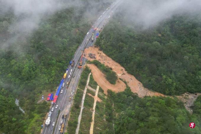
On April 30th, China Shenzhou No. 17 was successfully returned to Earth by group; on May 1st, the road of Meida high -speed in Guangdong, China collapsed, at least 23 cars fell, and 48 people were confirmed to die, 30 people were injured; China was Zheng Zhengzheng Zhengzheng; China was Zheng Zheng Zheng Zhengzheng was Zheng Zheng; China was Zheng Zhengzheng.Carry out hidden highway investigations.
These three things seem to be unrelated, but they point out an important application direction of Chinese outer space technology: the safety of using satellite monitoring technology on monitoring infrastructure and important buildings.
Globally, satellite technology is currently mainly used in communication and weather forecasts.In addition, Europe and the United States and China are applying satellite technology to the security and operation monitoring of the State Grid.For example, in 2018, the European Aerospace and European large power grid companies jointly carried out spatial technology to be used in the research of power transportation and operational safety. It is planned to achieve the large -scale application of spatial technology on Pan -European Power Grid in 2025;Satellite communication terminals are installed on the power grid facilities of the two countries, used to detect and forecast hidden dangers, and monitor the grid in real time; China Southern Power Grid uses low -orbital satellite Internet technology to monitor the remote mountainous lines that traditionally belong to the "communication blind zone" to achieve realizationThe power transmission system is "considerable, measured, and controllable."
The power system can use satellite technology on a large scale, mainly due to the high incidence of power transmission system failure and large impact. Satellite technology can meet comprehensive needs such as real -time monitoring, operation management, line inspection and emergency protection.
The little known is that remote sensing image technology (also known as satellite images) in satellite technology (also known as satellite images) has unique advantages in disasters such as landslides, buildings (such as reservoir dams, high -rise buildings) collapse.This is mainly through the long -term follow -up images of the target objects, analyzed the collected pictures, discovered the trend, and issued an alert.For example, through comparative analysis of long -term satellite image pictures, we can find hidden dangers such as the foundation movement of the high -voltage line hanging tower and the tilt tilt tilt, so as to take corrective measures.
Unfortunately, except for the power industry, employees in other industries do not know much about this technology.Therefore, the British government's satellite technology application agencies have spared no effort to promote the application of satellite technology in disaster prevention to other industries; the remote sensing of the Chinese Academy of Sciences and the Digital Earth Research Institute are also making the same efforts.
One reason why other industries are unfamiliar with this technology is that image analysis needs to collect a large number of pictures for a long time, involving a large amount of technology and equipment investment, and a large number of analysis time, which costs high costs.However, with the significant reduction of rocket launch and satellite manufacturing costs, and the development of artificial intelligence, especially the development of machine learning, the threshold for collection and analysis of remote sensing images has been greatly reduced.There are already a large number of small artificial intelligence technology application companies in Europe and the United States, which specializes in providing remote sensing image analysis services for power companies.
Due to the small probability of disasters, other industries may feel that it is not necessary to apply this technology.The problem is that once disasters of infrastructure and important buildings occur, it is a matter of life.Some highway construction operators pointed out after the Mei Da accident accident: "Pre -judgment of potential landslide areas, and some satellite monitoring methods can also be directly fed back to the security center for warning."It must be pointed out that according to the short -term collection of satellite imaging analysis, it can achieve a certain degree of prediction and warning, but the most effective is long -term satellite image analysis to accurately reveal the trend of the physical location of the target object.For example, the Institute of Remote and Digital Earth Research of the Chinese Academy of Sciences pointed out: "The spatial information (analysis) of long -term sequence high -rise buildings (including various infrastructure) has significant scientific and practical value."Believe.
It should also be pointed out that it is not enough to rely on remote sensing technology monitoring and artificial intelligence analysis. The management department must also use helicopters or drones regularly to carry out air photography near the target object.To achieve the monitoring of the three -in -one in the sky and earth, the disaster can be predicted to the greatest extent.
One of the focus of disaster prevention is to prevent reservoir dams from collapse.In this case, in addition to traditional strict prevention, the local government of Chinese governments should quickly use satellite remote sensing technology to monitor these important infrastructure.In the long run, the world has entered a new normal of disaster weather and extreme weather.The Chinese government and enterprises should jointly jointly scientific research units to monitor infrastructure and important buildings with remote sensing technology to improve their safety.
In short, the satellite remote sensing is an effective tool for achieving the Chinese government's guidance guidelines for disaster relief and disaster relief. It is a spatial technology that effectively enhances the well -being of the people.
The author is the president of the British Three Rubber Technology Co., Ltd. and the company and scientific research institutions mentioned in the text.


