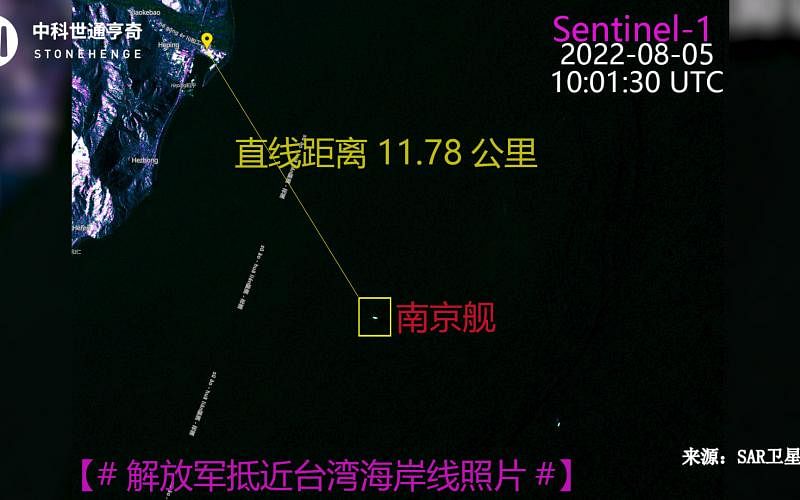
As the mainland Chinese fighter and warships continued to break through the midline of the Strait and near the coast of Taiwan's island, Shitong Hengqi, a mainland technology company, announced a satellite map, saying that the PLA Nanjing Ship was in the waters near Hualien, Taiwan.The distance of Hualien Peace Power Plant is only about 11.78 kilometers.
Shitong Hengqi announced a satellite map taken by SAR satellite on August 5th on the official Weibo on Saturday (6th).Shitong Hengqi said that according to the tracking of the multi -domain situation system, "On August 5th, the Nanjing ship moved in the waters near Hualien, which was about 11.78 kilometers away from the chimney of the Hualien Peace Power Plant."
The Mainland official media has reported that the distance of 11.78 kilometers means that the PLA warships have entered the 12 nautical miles (about 22.22 kilometers) of Taiwan.
According to the introduction of the official website of Hualien Heping Heping Fire Power Plant, the plant is located in the Heping Heping Industrial Zone of Xiulin Township, Hualien County. The capacity of two devices is installed with a capacity of 660 kilowatts.Ten thousand kilowatts.The chimney of the power plant is as high as 250 meters, and the chimney is painted with Taiwan Aboriginal totems.
Earlier, in a group of photos released by Xinhua News Agency, a PLA soldier observed the telescope on the warship deck. The photo was a ship near the photo, and the coastline and the mountains in the distance.At the same time, there is a white columnar on the coastline.
According to the Taiwan United Daily, this white column was later confirmed to be the chimney of the Hualien and Heping Headian Power Plant; the Hualien fishermen speculated that the PLA warships were about 16 nautical miles (about 30 kilometers) from the Taiwan coastline (about 30 kilometers).